Welcome to part two of my blog on Massawepie Lake. We left off with our stop at the trail to Pine Pond.
Here is a photo of that well marked trail on the west side of the lake, on one of the fingers that extend out to the west:
Along the trail, we saw a burl on a tree, and of course I had to take a photo of it:
Here is a close-up of the burl:
As I mentioned in part one, the trail to Pine Pond was uphill from Massawepie Lake, but it wasn't real steep. Though, keep in mind, we were not carrying our kayaks. We didn't care to "pond hop" on this day, so we left the kayaks on Massawepie and took a walk up the trail to tiny Pine Pond. On the way, a plant caught my eye, so I snapped a shot. I love how the red berries and dark green, glossy leaves stand out against the reddish brown of the pine needles and earth.
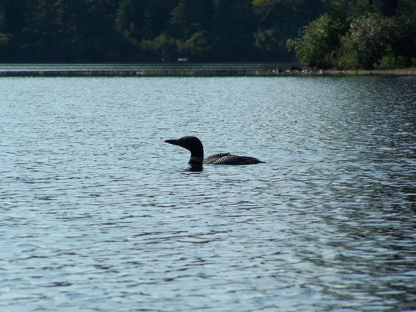
Here is one shot of Pine Pond:
We saw a frog in the shallows at the edge of the pond when we went for a closer look. He is doing a good job with his camouflauge!
And here are a couple of mushrooms near the trail at Pine Pond:
Here is my favorite photo of Pine Pond. It seems to have "mood" to it-- I think it expresses this pretty little pond perfectly-- serene, wild and beautiful. What do you think?
After our short walk and our visit to the pond, we headed back down the trail to Massawepie Lake where we had left our kayaks:
Usually when we stop to stretch our legs, we find a place to sit and eat our lunch. But I don't think we did on this day. Since we got a late start, I think we may have eaten our picnic lunch on the way, or before we got on the water. At any rate, this would be a nice place to have a drink and a snack or your lunch. Just pull up a log and have a seat!
Once we were back on the water, we headed straight for the put-in. The wind had picked up and we were ready to get off the water.
In the car, we decided to drive south on the camp road, knowing we'd be able to see one or two more of the ponds in the area. We followed the narrow dirt road and it seemed as if we were driving on the ridge of a very large esker. It was sandy and both sides fell steeply away. The short drive was worth it as we came to Horseshoe Pond:
Although we didn't get our kayaks out and paddle here, it's easy to see why someone might want to. The put-in requires a steep downhill walk (uphill when you're getting out) but it may be worth your while. This next photo will prove it even more:
There is also a put-in for Boottree Pond, which we didn't visit. And in the area are three other ponds, though my information doesn't show any access to these: Catamount Pond, Round Pond, and Long Pond.
It is a beautiful area, and a great place for a Boy Scout camp. I will leave you with one last photo of Horseshoe Pond.
I hope you've enjoyed the photos of Massawepie Lake and some of the ponds surrounding it. Please use the "reactions" buttons to let me know what you liked about this blog post. Thanks, and keep thinking spring!
Monday, February 21, 2011
Friday, February 11, 2011
Massawepie Lake, part one
This is the first photo I took of Massawepie Lake, facing west from the put-in on it's eastern shore. We did not arrive until the late morning, so the ripples you see are due to the slight breeze. (If you're a kayaker in NY state (maybe this is true everywhere?) or you've been reading this blog, you know that winds pick-up as noon time approaches and the atmosphere heats up, then die back down toward evening.) This lake is owned by the Otetiana Council of the Boy Scouts of America, along with the adjoining ponds of Catamount, Round, Long, Horseshoe, Boottree and Pine. The lake is also the source of the Grass River. Because the Boy Scouts use this area, it is CLOSED to the PUBLIC from the LAST WEEK in JUNE to the LAST WEEK in AUGUST. So, if interested in paddling here, go early in the season or late in the season. The lake can be reached via Route 3, about 12 miles west of Tupper Lake.
When we paddled here in September of 2009, there was a sailboat of some type out on the water near the northern part of the lake. This is one of our favorite types of lakes-- the ones where no gasoline motors are allowed!
I hadn't yet realized that a photo of the put-in area for each place we paddled was a good idea, so I don't have one for Massawepie Lake, but it's a sandy area and I do not remember any problems at all with our entry. By the way, is anyone as intrigued as I am about the lake's name? It sounds perfect for a boy scout camp-- think of the camp songs using that name! The Adirondacks does have some interesting names, a lot of them seem to be people's names or describe the lake or mountain (Nicks Lake, Whiteface Mountain) but this one could be a Native American name... if I find out anything I'll let you know (or if YOU know, then let ME know!) Ahh.... Inquiring minds like mine just can't let a question like that go. Thank you Wikipedia for the info: massawepie is Iroquois for "the beaver's lake." There-- don't you feel better? I do! (Except all of the 4th graders in NY state probably already knew this!)
The lake is practically surrounded by hemlocks. I believe this photo is along the eastern shore.
Here is my husband as we head into one of the nooks and crannies at the south end of the lake. Did I ever mention how the bright, late morning and early afternoon sun is not too conducive to good picture taking? (At least with my point and shoot.)
Here is a photo of the western shore, just across from the camping area on the lake. It looks like there is a clearing in the trees. We could imagine the boy scouts canoeing across to this pretty spot for some kind of gathering.
One of the most interesting places for us was the southwestern part of the lake where there was tiny island, a couple of peninsulas, a footbridge, etc. Here is the approach to that area:
And here is one of the peninsulas-- or maybe this was the island-- sorry, it's been too long for me to be positive. But isn't it gorgeous? And notice that the water is much more calm in this protected area. The second photo is another of the peninsulas in this area near the Grass River.
This is a pretty shot taken looking north, I think, from the southern area of the lake:
Here is one of the "dead end" areas near the Grass River. We were on our way to check out the river.
This is the footbridge over the Grass River. You can carry over this bridge and float down the river as it leaves Massawepie Lake.
Here is a close-up of the bridge which shows how shallow and plant-filled the river is as it flows out of the lake. We decided not to paddle down the river.
One more shot of the Grass River flowing out of Massawepie Lake:
And a shot I took of the footbridge's boards. I like the grain, the space between the boards, and how the nails are sticking up a bit.
Once we left the footbridge and the Grass River, we paddled up one of the fingers of water that I knew, by my paddling map, would lead us to a trail to Pine Pond. Here is a photo of the "end" of that finger, before we got off the water at the trail:
As you can see, there was still a whole lot of plant life in the water in September. We took out our kayaks at the Pine Pond trail and left them for a very short walk to the pond. Here is the well marked trail:
There are a few places on Massawepie Lake that will get you to trails leading to some of the ponds surrounding it. This is one, to Pine Pond is on a western "finger" of the lake and there are trails to Boottree Pond and Horseshoe Pond as well on the southern shores. We like to stretch our legs, but putting in and taking out at multiple spots is not our idea of a great paddling day. However, if you like that type of thing, this is a perfect spot for it. (There are many others with lots more mileage, both on the water and the carries, further north--St. Regis Canoe Area and Fish Creek Loops to name two, where we haven't yet been paddling.)
The trail to Pine Pond is short, but uphill. Since we weren't taking our kayaks, it was a pleasant way to stretch our legs. It's a tiny but pretty pond and I'll end part one of Massawepie Lake with a photo of it:
Keep thinking "spring" and maybe we'll make it happen sooner. I can't wait to be back on the water. How about you?
Sunday, January 30, 2011
South Pond, part two
If you are interested in birds, please go back to Crooked Creek, part one for a correction on my bird identification. What I thought was a spotted sandpiper is a bird rare to NNY-- a Red-necked Phalarope.
Thanks to a fellow birder and blog follower for the information. I appreciate it!Welcome back to South Pond! Do you feel the warm July breeze when gazing at the photos? If I close my eyes and visualize, I can almost smell the lake water and the pines... hurry up summer!
Below is a photo of the island (on the right) we stopped at to stretch our legs and eat lunch. Behind the boulder is a shallow area. It's mostly rock, but the water is shallow and we were able to land here without a problem.
There is a very nice campsite here although the flat area for a tent is quite small. Pine needles blanket the ground and there are boulders here and there, such as this one:
Often we see mushrooms when we take a kayaking break to stretch our legs. It makes sense because we are usually in the woods during these breaks. We've seen some interesting ones, mostly it's their colors that attract me. Here is a very bright one. I know nothing about mushrooms, but I wonder if it's vibrant color is a warning to not eat it? Probably not, since I know some poisonous ones are white... hmmm... if you know what kind of mushroom this is, let me know.
We took a walk along some paths through the island, checking out the lake from different vantage points. Although there are a lot of trees, the sun filters through the pine needles giving everything that speckled look that is so interesting to the eye. We even found the "potty"-- someone had brought a toilet seat and fixed it over a hole in the ground.... you never know what you might find! Here is an example of the sun coming through the trees on the path:
After our walk on the island, we ate our picnic lunch at the campsite, using the handy log stools someone had provided. There was even a crude table for us to place our cooler on. The day was peaceful and we both felt that if the day were any warmer, the sun any hotter, we might have taken a nap right then and there.
After paddling along the backside of this island, we turned and headed east-northeast. Here is a photo of some of the islands, looking in that direction (I think!) I'm pretty sure the one we stopped at is on the left. But, it's been a year and a half, so I may be wrong.
By the time our morning was edging into afternoon, the wind had picked up a bit, as you can see by both the photos above and below this text. Clouds blew across the sun at times, giving a blue-gray look to the water as well as the mountains in the distance. (This view is pretty much looking east, I believe.)
Here is another with the hazy clouds covering the sun and the wind causing ripples on the lake. The mountain is Blue Mountain. See my blog posts of Lake Durant and Rock Pond for a few more photos of Blue Mountain, looking at it from a southerly direction. Here is the link to part one: http://quietkayaking.blogspot.com/2010_05_01_archive.html
Below is a photo of my husband. His hips bother him, so throwing his legs out of the kayak once in a while changes the pressure on his hips, giving them a break. We do this all the time, but I can't say that it's "safe" with other kayaks. Test this out in warm shallow water before trying it elsewhere-- we have wide, extremely stable kayaks, allowing us to do a bit more moving around and repositioning than some other kayaks.
Anybody recognize this shot? First one to comment correctly on why they recognize it will get their name (if they wish) and a "Congratulations!" in my next blog post!
We cut off the southeastern corner of the lake and headed back toward the put in as the water rippled and the breeze picked up. It had been an enjoyable morning and early afternoon. We were so happy to have seen the osprey and spent a lot of time watching him/her. We felt that it was a great kayaking day. And before we got back to the put-in it got even better:
A loon! We hadn't seen him or her all day as we paddled around South Pond, but it suddenly appeared near us. They are master divers and swimmers, able to hold their breath underwater for many minutes at a time in search of some fish to eat. We watched this one and with the zoom on my camera, I got a few shots.

As we trudged up the hill, sliding our kayaks along the pine needle path, we were so buoyed by the sight of the loon as we were ending our paddle that the climb didn't bother us a bit!
I plan to blog on another location within a week or two, so come back and check it out. Thanks for reading.
And all of you who kayak or are planning to this year, keep dreaming of warm weather and sooner or later, it will happen!
Thursday, January 27, 2011
South Pond, part one
If you are interested in birds, please go back to Crooked Creek, part one for a correction on my bird identification. What I thought was a spotted sandpiper is a bird rare to NNY-- a Red-necked Phalarope.
Thanks to a fellow birder and blog follower for the information. I appreciate it!Hello and "happy" winter! I suppose I shouldn't grumble... I live in Northern New York and when it gets down to 27 below zero, it's not much of a surprise. That was Monday's temperature at 7:00 a.m. (January 24th.) Our attempt to kayak at Moss Lake- my last blog post- was the end of our kayaking season. Now I feel like we're more than halfway through the no-kayaking season. I hope I'm right! I promised to blog about locations we've been to in the past over this winter but the holidays, visiting family, and my commitments to some community music groups have once again wreaked havoc on my good intentions.
I will try to give you a taste of what will be in store for all of us once the snow and cold temps. have left and the sun is bright and warm, the leaves and grass green....
This is South Pond, looking south-southeast. Blue Mountain is in the background. The July 2009 morning we paddled here the day began with very calm water and only a few boats on the water. Most of the land surrounding South Pond is part of the Forest Preserve or is state land. There are some homes on the north-northwestern shore and the islands have some bare campsites. To get to South Pond, drive north on Route 30, about 6 miles from the town of Blue Mountain Lake. The parking area and South Pond are on the west side of the road.
There is one important disadvantage to paddling here, but we felt it was worth it. The trail down to the water is a very steep decent from the unloading area (you have to park down the road a bit after taking your kayaks or canoes off.) The trail is smooth, but it's quite a ways down to the water. My husband's red kayak is a bit more than halfway to the water (the light color behind the trees.)
One other thing to be aware of is the large submerged boulders. We did not scape bottom on any of them since we knew to look for them. Most, if I remember correctly, were on the northern shore area. Submerged boulders are not that unusual for Adirondack lakes, so this is really not a big deal and isn't much of a problem for flat water paddlers-- I just wanted you to be aware.
We traveled counter-clockwise along the shoreline from the put-in. There are several houses in this area and any traffic on Route 30 can be heard in this area, but it didn't take long for the noise to fade as we paddled along. Here is a photo of the northern shoreline area:
The lake is sort of triangular shaped with a few islands on its wide southern area. Its size isn't much more than 1 mile wide along the southern side, but almost that long from the northern points to the southern shore, so it's not tiny. One of my guidebooks says that wind can be a problem. By the time we got off the water, some waves were forming, but most of the morning it was, if not smooth like the photo above, then just "ripple-y."
The photo below shows some of the northwestern shore. This is where the houses were located. Luckily, thick woods kept the man made structures partially hidden.
Here is a shot as we approached the southern shores. The islands, from this point of view, looked like part of the shoreline to us.
Continuing our paddle toward the south shores of South Pond, we looked up in a tree whose top had been sheared off and saw an osprey nest.
If you look closely, you will see an osprey in the nest. We watched him/her for a long time, hoping to see the fisherman grabbing his lunch. But, no such luck. We were able to get a few photos though, as it flew to another tree and perched there.
Here is one I cropped. It's not real clear, but gives you a better idea of their shape and markings.
One of the best parts about flat water kayaking, other than the peacefulness and the relaxation we enjoy, is the opportunity to see wildlife such as the osprey. We always feel like we "hit the jackpot" when we are fortunate enough to observe animals and birds in their habitat as we paddle along. Even if the only wildlife we see are Canada geese or black ducks, we can't help but smile-- it adds another dimension to our kayaking pleasure!
I'll end the first half of this blog on South Pond with a close-up of one of the islands. We stopped here to stretch our legs and eat our lunch. Next time I'll start with a few more photos of this island which included a campsite near the water.
Stay warm, pray for spring to come early, and I'll "see" you next time for part two!
Subscribe to:
Posts (Atom)