Sunday, January 30, 2011

South Pond, part two


If you are interested in birds, please go back to Crooked Creek, part one for a correction on my bird identification.  What I thought was a spotted sandpiper is a bird rare to NNY-- a Red-necked Phalarope.
Thanks to a fellow birder and blog follower for the information.  I appreciate it!

Welcome back to South Pond!  Do you feel the warm July breeze when gazing at the photos?  If I close my eyes and visualize, I can almost smell the lake water and the pines...  hurry up summer!

Below is a photo of the island (on the right) we stopped at to stretch our legs and eat lunch.  Behind the boulder is a shallow area. It's mostly rock, but the water is shallow and we were able to land here without a problem.

There is a very nice campsite here although the flat area for a tent is quite small.  Pine needles blanket the ground and there are boulders here and there, such as this one:


Often we see mushrooms when we take a kayaking break to stretch our legs.  It makes sense because we are usually in the woods during these breaks.  We've seen some interesting ones, mostly it's their colors that attract me.  Here is a very bright one.  I know nothing about mushrooms, but I wonder if it's vibrant color is a warning to not eat it?  Probably not, since I know some poisonous ones are white... hmmm... if you know what kind of mushroom this is, let me know.


We took a walk along some paths through the island, checking out the lake from different vantage points.  Although there are a lot of trees, the sun filters through the pine needles giving everything that speckled look that is so interesting to the eye.  We even found the "potty"-- someone had brought a toilet seat and fixed it over a hole in the ground.... you never know what you might find!   Here is an example of the sun coming through the trees on the path:
                                                                                                                                                           

After our walk on the island, we ate our picnic lunch at the campsite, using the handy log stools someone had provided.  There was even a crude table for us to place our cooler on.  The day was peaceful and we both felt that if the day were any warmer, the sun any hotter, we might have taken a nap right then and there.


After paddling along the backside of this island, we turned and headed east-northeast.  Here is a photo of some of the islands, looking in that direction (I think!)  I'm pretty sure the one we stopped at is on the left.   But, it's been a year and a half, so I may be wrong.


By the time our morning was edging into afternoon, the wind had picked up a bit, as you can see by both the photos above and below this text.  Clouds blew across the sun at times, giving a blue-gray look to the water as well as the mountains in the distance.  (This view is pretty much looking east, I believe.)


Here is another with the hazy clouds covering the sun and the wind causing ripples on the lake.  The mountain is Blue Mountain.  See my blog posts of Lake Durant and Rock Pond for a few more photos of Blue Mountain, looking at it from a southerly direction.  Here is the link to part one:  http://quietkayaking.blogspot.com/2010_05_01_archive.html


Below is a photo of my husband.  His hips bother him, so throwing his legs out of the kayak once in a while changes the pressure on his hips, giving them a break.  We do this all the time, but I can't say that it's "safe" with other kayaks.  Test this out in warm shallow water before trying it elsewhere-- we have wide, extremely stable kayaks, allowing us to do a bit more moving around and repositioning than some other kayaks.


Anybody recognize this shot?  First one to comment correctly on why they recognize it will get their name (if they wish) and a "Congratulations!" in my next blog post!


We cut off the southeastern corner of the lake and headed back toward the put in as the water rippled and the breeze picked up.  It had been an enjoyable morning and early afternoon.  We were so happy to have seen the osprey and spent a lot of time watching him/her.  We felt that it was a great kayaking day.  And before we got back to the put-in it got even better:


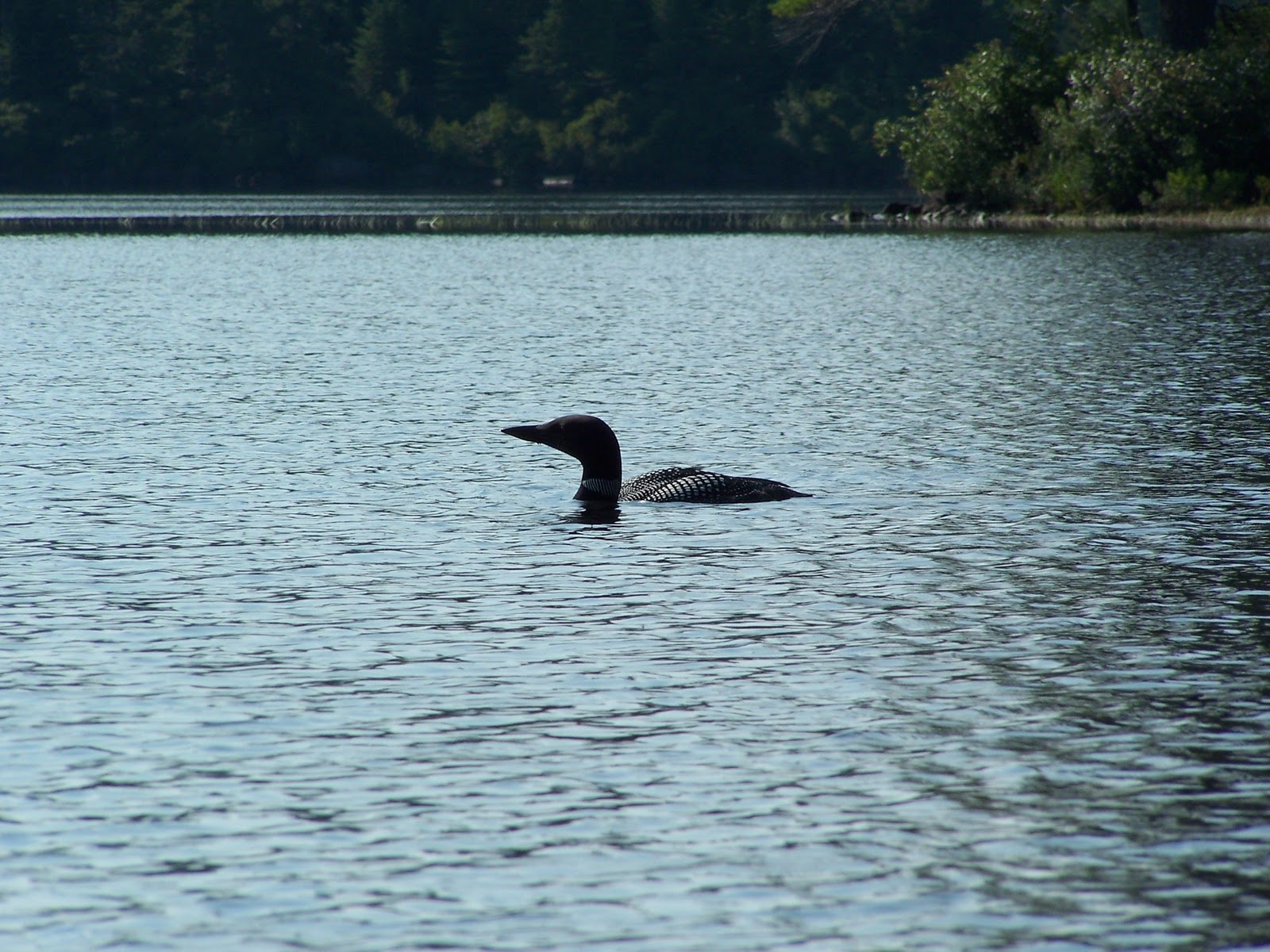
A loon!  We hadn't seen him or her all day as we paddled around South Pond, but it suddenly appeared near us.  They are master divers and swimmers, able to hold their breath underwater for many minutes at a time in search of some fish to eat.  We watched this one and with the zoom on my camera, I got a few shots.


The photos aren't great due to the lighting, but they're a great reminder of our day on South Pond, and how lucky we were to have seen not only an osprey but a loon as well!

As we trudged up the hill, sliding our kayaks along the pine needle path, we were so buoyed by the sight of the loon as we were ending our paddle that the climb didn't bother us a bit!

I plan to blog on another location within a week or two, so come back and check it out.  Thanks for reading.
And all of you who kayak or are planning to this year, keep dreaming of warm weather and sooner or later, it will happen!

Thursday, January 27, 2011

South Pond, part one

If you are interested in birds, please go back to Crooked Creek, part one for a correction on my bird identification.  What I thought was a spotted sandpiper is a bird rare to NNY-- a Red-necked Phalarope.
Thanks to a fellow birder and blog follower for the information.  I appreciate it!

Hello and "happy" winter!  I suppose I shouldn't grumble... I live in Northern New York and when it gets down to 27 below zero, it's not much of a surprise.  That was Monday's temperature at 7:00 a.m. (January 24th.)  Our attempt to kayak at Moss Lake- my last blog post- was the end of our kayaking season.  Now I feel like we're more than halfway through the no-kayaking season.  I hope I'm right!  I promised to blog about locations we've been to in the past over this winter but the holidays, visiting family, and my commitments to some community music groups have once again wreaked havoc on my good intentions.

I will try to give you a taste of what will be in store for all of us once the snow and cold temps. have left and the sun is bright and warm, the leaves and grass green....

 
 This is South Pond, looking south-southeast.   Blue Mountain is in the background.  The July 2009 morning we paddled here the day began with very calm water and only a few boats on the water.  Most of the land surrounding South Pond is part of the Forest Preserve or is state land.  There are some homes on the north-northwestern shore and the islands have some bare campsites.  To get to South Pond, drive north on Route 30, about 6 miles from the town of Blue Mountain Lake.  The parking area and South Pond are on the west side of the road.


There is one important disadvantage to paddling here, but we felt it was worth it. The trail down to the water is a very steep decent from the unloading area (you have to park down the road a bit after taking your kayaks or canoes off.)  The trail is smooth, but it's quite a ways down to the water.  My husband's red kayak is a bit more than halfway to the water (the light color behind the trees.)


One other thing to be aware of is the large submerged boulders.  We did not scape bottom on any of them since we knew to look for them.  Most, if I remember correctly, were on the northern shore area.  Submerged boulders are not that unusual for Adirondack lakes, so this is really not a big deal and isn't much of a problem for flat water paddlers-- I just wanted you to be aware.

We traveled counter-clockwise along the shoreline from the put-in.  There are several houses in this area and any traffic on Route 30 can be heard in this area, but it didn't take long for the noise to fade as we paddled along.  Here is a photo of the northern shoreline area:


The lake is sort of triangular shaped with a few islands on its wide southern area.  Its size isn't much more than 1 mile wide along the southern side, but almost that long from the northern points to the southern shore, so it's not tiny.  One of my guidebooks says that wind can be a problem.  By the time we got off the water, some waves were forming, but most of the morning it was, if not smooth like the photo above, then just "ripple-y."


The photo below shows some of the northwestern shore.  This is where the houses were located.  Luckily, thick woods kept the man made structures partially hidden.


Here is a shot as we approached the southern shores.  The islands, from this point of view, looked like part of the shoreline to us.


Continuing our paddle toward the south shores of South Pond, we looked up in a tree whose top had been sheared off and saw an osprey nest.


If you look closely, you will see an osprey in the nest.  We watched him/her for a long time, hoping to see the fisherman grabbing his lunch.  But, no such luck.  We were able to get a few photos though, as it flew to another tree and perched there.


Here is one I cropped.  It's not real clear, but gives you a better idea of their shape and markings.


One of the best parts about flat water kayaking, other than the peacefulness and the relaxation we enjoy, is the opportunity to see wildlife such as the osprey.  We always feel like we "hit the jackpot" when we are fortunate enough to observe animals and birds in their habitat as we paddle along.  Even if the only wildlife we see are Canada geese or black ducks, we can't help but smile-- it adds another dimension to our kayaking pleasure!

I'll end the first half of this blog on South Pond with a close-up of one of the islands.  We stopped here to stretch our legs and eat our lunch.  Next time I'll start with a few more photos of this island which included a campsite near the water.


Stay warm, pray for spring to come early, and I'll "see" you next time for part two!

Tuesday, November 2, 2010

Moss Lake

Hello and welcome back to my blog!  I took a couple of weeks off from writing, hoping all the while that I'd have a trip to share with you.  Well, we tried-- but mother nature did not cooperate.  However, I have photos from our "try" at kayaking Moss Lake, as well as a very few photos from another trip on this pretty but small lake from a few years ago.

Here is what the trail to the put- in looks like in the damp and rain of a Sunday in October.  (By the way, it was partly cloudy, with blue skies and nice sunshine when we loaded up the kayaks and headed to Moss Lake, which is near Eagle Bay, north of Old Forge.)  It didn't stay that way for long.


Moss Lake used to be the site of a girl's camp, so there is a trail all the way around the lake.  It was used back then for horseback riding.  It makes a nice, fairly flat walk.  But I wouldn't advise a stroll here in late May or June.  The black flies can be bothersome.

At the parking lot there is a sign explaining the history of the camp with a map of the trail as well.

Camping is allowed but I believe you need a permit.
Here is the put-in at the lake, less than 100 yards from the parking lot.


I'm sure you're thinking the photo is pretty washed out... well, it was.  But the color was not the problem.  It's RAIN and FOG that were the problem.   The lake has a pretty island with an osprey nest at the top of a dead tree.  Here is the island as seen from the put-in:


And a close up:


Does it look cold to you?  Well, it was.  The rain was drizzly at the lake and the temperature had steadily declined the further we traveled on our way to Moss Lake.  I think it was 42 degrees when we got out of our car and (quite smartly) decided to NOT begin removing the straps on the kayaks.  We went to check out the lake and to see if the weather showed any signs of improvement.

Before you get the idea that Moss Lake is a dark and dreary place, let me show you what it looks like in June when the sun is out and it's warm and bright! 


There are hills surrounding the lake, so it feels a bit secluded and as you can see, is a very pretty little lake.

I only have a few photos from our earlier trip to Moss Lake because at the time we went, I didn't yet trust myself to hang onto my "good" camera, so we used a 35 mm point and shoot, and I only scanned some of the photos into my computer.

Here is another photo from that trip in June:


Did you notice that I said "trip in June" yet a few paragraphs before that, I advised not paddling here in May or June???  Well, we didn't know the black flies would be so bad that day.  Our trip was not long because we found ourselves unable to speak, breathe or even sometimes keep our eyes open on the lake when we ran into a cloud of the pesky things!  It ended up not being a very pleasant paddle, even though as you can see, it started out fairly nice.  I think the wind died down, or maybe it was when we got closer to shore... not really sure when or why the black flies got so thick.  I just know I had them in my eyes and nose and that is not good at all.

If you paddle around the lake counter clockwise from the put-in, you will come to a small sandy beach which also has a deck area and a trail up to a separate parking lot for handicapped persons.  This seems to be a very nice place to go if you are in a wheelchair or would like someone who is disabled to be able to enjoy a view of the lake.  It is just a trail- not paved- but it looked to us as if it would be passable in a wheelchair, at least with some assistance.

About half way around the lake; continuing in the clockwise direction; is a footbridge.  This outlet is supposedly paddle-able, but we have not had the opportunity to find out yet.  You do have to get out of your kayak and lift over the bridge or go around it-- it's not high enough to pass under.

There are places along the lakeshore where the trail is very near, and other spots where the trail is a bit further from the water.  Since the weather did not seem to be improving, we decided to take a walk on the trail.  Here is a photo taken near the put-in before we got on the trail:


And one of a marshy area not far from the put-in:


Once on the trail, we crossed several streams winding their way to the lake.  Here is one:


And here is another:


As we walked around the lake, the drizzle turned into mist... it wasn't looking promising, even for a walk in the woods.  Here is the deck area at the sand beach which I mentioned above:


And here is the lake and the island from that area:


And a close-up of the island.  Do you see the osprey nest in the top of the dead tree?


Here is a photo of that same nest, taken on our previous paddle here, from the opposite side of the island:


If you look closely you will see the white head of an osprey just left of the middle of the nest.  Both parents were in the nest when I took this photo.  We were near the island and they were not happy.  One swooped down (even though we were about 70 feet below them, they still didn't like our presence) and let us know that we needed to go.  We obliged them, not wanting to upset them and understanding then that they must have babies in the nest.  Also, at about the same time the osprey momma or daddy warned us, I floated right into a cloud of black flies so thick that I saw black-- when I had my eyes open, that is.  I threw the camera in my lap and paddled like a madwoman, trying to get away from them!  We decided at that moment that we'd done enough paddling on pretty Moss Lake for one day in June.


Here is one more photo from the beach area:


And here are a few more photos of the area around the lake from our short walk.  It was very short because about 20 mins. into it, the misty rain became rain drops.  Rain and a temperature of 42 degrees is not pleasant, believe me, even in the woods along a nice trail.


We turned around and headed back to the car as the rain became steady, the drops bigger.  One thing about the gloom and the rain though, colors in the woods stand out.  Here is a fern I photographed on the way back to the parking lot:

So, I'd say that we've had some bad luck with Moss Lake.  We have friends who paddle here most every year.  It's a great location and so pretty, with easy entry from the sandy area at the put-in.  Don't let our experience with the black flies or the rain keep you from checking Moss Lake out.  You won't be disappointed.  I'll leave you with one last photo of Moss Lake from our June trip a few years ago:


Hopefully we'll get a chance to do an enjoyable full paddle of Moss Lake next season.  For those of you in the south or those who wear your spray skirts and dry suits, happy kayaking!  For the rest of us, kayaking season is over now.  (Yes, we've had snow here, though it only stuck on the grass for a few hours.)  I plan to blog every week or two on a location that we've visited in the past.  I have tons of photos, and many great memories, tips and descriptions to share with you through the dark days of winter.  So join me again soon!

Wednesday, October 13, 2010

Crooked Creek, part two

OK.  Back to Crooked Creek! Before I continue describing the rest of our trip, I'd like to back-track all the way to the beginning of part one.  Before I took the first photos, before we even had the kayaks off the car, we had a pretty neat experience.  I didn't have the camera out yet, so you'll have to picture this in your mind...

We had just pulled over near the bridge on Route 1.  My husband began untying the straps, and I started transferring our lunch from a cooler to a smaller carrier.  All of a sudden I heard something behind me and turned to catch the back end of a deer as it swerved away from me.  It almost ran right into me!  My husband saw the deer too, but too late to warn me.  The doe veered around the car, then up on the road and walked straight down the middle of the bridge, crossing and going into the woods.  Imagine the photos I could have had...  oh well...

So, we floated back downstream toward the bridge.  These rocks are in the area where the spotted sandpiper was hanging out.  There are places where you'll see both rocks and marsh areas juxtaposed, but not all the time, so it's interesting to see.


Although this next photo doesn't include much of the color of fall, the blues of the sky and water are so strong and contrast with the tan-brown of the plants that I had to post it.


We've now paddled back to the put-in at the bridge and are heading further downstream.  We didn't have much of a plan.  All we knew is that we were getting hungry, and that we did not relish a long hard paddle back against the wind and current.  The thought of this made us pay closer attention to the time as we headed downstream.  We did not want to get so engrossed in our downstream paddle that our trip back was no fun.  Around a bend in the creek, we saw a muskrat swimming toward us.  When he caught sight of us, he turned very quickly toward shore and was hiding in the reeds by the time we passed him.

As we paddled along and the wind died down, we heard a hawk's whistle.  Looking up, we saw one marsh hawk (Northern harrier) join another for a moment.  Then they split up again, and we only saw one.  He/she seemed to be enjoying the breeze, gliding around on the air currents.  We watched for a long time and at one point, he seemed frozen in place in the sky.  That was really cool to see.  I have watched a seagull do that once-- believe it or not, very nearby on the St. Lawrence River--  but had never watched any other bird just kind of "hang" in the air.  That was probably the highlight of the paddle-- well, maybe not-- the deer incident is close!


Here is one of the beaver houses we saw along the creek. This was one of the few spots on the creek where the current seemed weaker and the wind more calm.


Rounding a bend in this same calm area, we saw a great blue heron.  The photo isn't great, but they're such neat looking birds that I have to post his picture:


I have another shot of him as he flew off-- he was very shy.  I won't post that photo because it's all browns and grays like the one above.  Just imagine him flying away, off to the left...

This area was one of my favorite of trip.  It was around a big bend in the creek, marsh on one side, rocky shore on the other, and calm, shallow water with lilly pads.  We want to come back here and paddle in the summer to see everything green.
  I purposely put these similar photos near each other.  Which one do you like better?
                      

There are more rocky areas on west/south side of the creek as you go along toward Route 12.  We like rock formations and thought the nature-made rectangular blocks were neat.               


Our bellies had been rumbling for about an hour, so we finally decided to pull off somewhere.  If you paddle here, keep in mind that there are not many places to get out of your kayak and stretch or eat your lunch.  Maybe in low water there might be some shore areas, but there weren't any as we paddled.  What we found was a rock ledge that looked like a possibility.  It took some maneuvering, but we were able to land here.  My husband is in the background, wearing MY hat.  Guess he thinks he's funny!  (Actually, he did look pretty comical, considering his hat of choice is a baseball cap.)


As we sat eating our lunch, I looked up over my shoulder and saw the gorgeous blue sky through the pine tree's branches and needles and had to go get the camera from the dry bag.  Here is the resulting photo:


The wind blew in gusts at times as we ate, convincing us that we would be in for a steady paddle back upstream.  The sun was also competing with the clouds.  I think I had hoped to make it to the bridge over Route 12, just as a marker to figure out how far we had gone.  But, we decided to head back instead of paddling further downstream.

On the way, we passed by just two camps downstream from the Route 1 bridge.  Both looked barely used or abandoned all together, but with it being October, we can't be sure they aren't just summer camps.  I forgot to mention that at the Route 1 bridge there are homes on that road, and several homes/camps upstream for less than a half mile.  After that we did not see any other buildings. (We went less than 2 miles upstream.)

Near one of the camps that looked abandoned, there was a man-made rock wall.  We paddle over to investigate and found this snake skin.  I thought it was the skin of a medium-sized snake, but look closely and you will see more of the snakeskin skin in the shadow between the first and second rocks, left to right.  Well, I guess the slang term "snake skin" isn't quite correct.  The term for shedding, wiki just told me is: ecdysis.  Either than or simply "moulting."  I did not find out what the "snake skin" is called, other than "shed scales."  At any rate, the snake must have been rather long, from what we could tell!  And obviously, this rock wall was a great home... or at least a good resting place!


Our paddle was almost over--clouds were blowing in over us and we were looking forward to getting off the water. Yet we were sad that this might be our last paddle of the year.  The clouds above us formed an interesting pattern so I snapped a shot:


Back at the put-in at the bridge, we did some more maneuvering to get out.  I managed by sidling up to the reeds and bank, using my paddle behind me to balance the kayak, and got out easily.  My husband did the same thing, with some extra balancing help from me while he got out.  No problem!  As I mentioned in part one, we're getting better at entries and exits.

Here is one last photo of Crooked Creek from the put-in as we were leaving.  It's such a pretty spot, with lots of wildlife:  deer, spotted sandpiper, ducks, muskrat, beaver (though we didn't see one,) and great blue heron.  This creek will be on our list of places to return to.  Next time, it'll be in the summer and hopefully without wind! 

 Here's hoping we get one more paddle in this weekend.  Cross your fingers for us.  And don't expect me to "go away" once our paddling is done for the year.  We've been to over 30 different places, and I've only blogged about 7 or 8 of them.  So I plan to fill you in on some of them!

Please feel free to use the "reactions" buttons if you don't have time to leave a comment.  Feedback is always appreciated.  Happy kayaking!