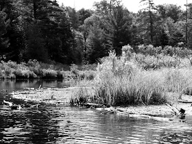
Forked Lake (pronounced with 2 syllables: Fork-Ed) is a large lake with, you guessed it-- forks. I call the three of them "arms" or "branches" because on a map they are narrow (relatively speaking) and each goes off in a different direction. One lies west, another east and one points north. Because 2 of the arms lie west to east, the wind can get some decent sized waves going. We encountered unusual (for northern NY) morning winds, creating rolling waves. I was disappointed, having come so far. The idea of paddling hard all day and being worn out was not appealing. But, the winds were not howling, just blowing steady for 5 or 10 minutes, and then dying down. We set out for the pennisula in the photo above. I think it's called Squirrel Point. There are posted signs on it. From this point, we could see north, up that arm and there was another smaller set-back area behind Squirrel Point.
Here is the view looking west after we were on the water:
And the view looking north when near Squirrel Point:
And the view looking east:
As you can see by the photos, the sun and clouds were competing against each other. You would think these are photos from 2 or 3 different paddles to this spot rather than all from the same day.
Because we weren't sure about the wind's chances of increasing, we did a quick look around from Squirrel Point. I wanted to be able to say that I knew where each arm of the lake was. Then I choose to go back to the western arm where there is an inlet. With the wind, this area would be the most calm. We'd still need to paddle back to the boat launch on the main lake, but at least we be rested from a relaxing paddle along the inlet and marsh area.
Brody, as usual, was up for the adventure!
Like most Adirondack lakes, Forked Lake is filled with rocks and boulders, both in the water and along the shore, sometimes lining the banks into the woods.
Below is a photo of the south end of the lake, our goal. The highest rounded peak is Pillsbury Mountain, according to my guidebook. In the middle of the photo at the waterline, do you see a line of white? It's hard to see in this photo. Anyway, the large light spots to the right along the water's edge are boulders and rocks, but in the middle is the marshy inlet, so no rocks there. It's actually waterlillies, which from this distance looked like one line of white on top of the water.
Here is an example of the rocks in the lake. The shoreline is also very jagged which makes it much more interesting to look at as you paddle along.
Brody certainly likes the varied scenery! Whenever we get close to the shore, he stands up and looks intently at the woods. I think he's hoping to see a chipmunk or a squirrel.
We heard lots of birdsong in the woods along the lake, but didn't see any birds flying. I spied this dead tree in the distance and hoped I'd find some kind of bird perched on it. No such luck.
I love cloud formations, and these just begged for a shot:
As you can see by the ripples in the water, the wind was definitely blowing. At times it seemed strong, maybe 7-10 mph. but it luckily didn't stay that way for any length of time.
Here is Brody with the cloud formation as a backdrop:
I got a kick out of these trees. They were taller than the trees around them and were a great indicator of the wind's usual direction on the lake.
We saw two different groups of loons in this southern area of the lake They all looked like adults, but there could certainly have been juveniles among them. We were too far away to see much except their heads sticking out of the water. We counted 7 in one group and 2 in another group. They called a few times, making Brody's pointy ears stick up just a bit straighter as he tried to see what the noise was and just who was making the racket. There were places along the lake where sound would echo back-- confusing Brody. We stayed out of the loons' way and they continued their fishing.
Here is another shot of cool cloud formations with Brody in the foreground:
We spied an empty DEC campsite along the shore before reaching the marsh area and inlet. It had 2 different sandy banks to pull a kayak or two out on and the tent area was flat. There was a picnic table and a stone fire pit. We made note of its location so that we could stop there on our way back. Lunch and a stretch of the legs were looking good by this time.
Another spot that would have been possible to land a kayak was here near the end of the lake before the marsh area. We thought the 2 boulders looked like dinosaur eggs or something, just sitting on the edge of the lake.
I will leave you with my favorite Brody photo of this trip. In fact, it's one of my favorites overall. I'm using this one as a screen saver right now. He's in the water lillies, which is where we will pick up part two of my description of our paddle on Forked Lake.
If you haven't checked out my website yet, please do. It's full of useful information with 20 locations completed and another 18 yet to go. Find it at: www.quietkayaking.webs.com
Happy Kayaking!


